Maysan is one of Iraq governorates, in the east of country bordering Iran, its capital Amarah located on the Tigris, the second largest city is Majar Al-Kabir, and before the year 1976 it was known as Amarah governorate. However, it is believed that the designation in origin was "kingdom of Mishan" then changed to Maysan.
Maysan in ancient history:
Most sources indicate that (Maysan) is a mini-state originated in the south of Babylon land under the protection of Seleucids (311 BC –247 BC), and when their power declined in the period between (223 BC–187 BC), Maysan became independent then had ascended gradually on power scale and became an important mini–state.
It was ruled by 23 kings for about 3.5 centuries, specifically between 129 BC –225 AD… and that she played a prominent role in Iraq's political and economic events during the period from the mid of second century BC to the first quarter of third century AD.
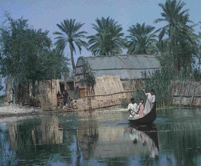
Maysan in Aramaic language means (swamps water)(stagnant water), also, Mayan hosts the tomb of (Uzayr prophet) who is sacred to both Jews and Muslims, and the tomb of Sharif Abeidallah bin Ali bin Abi Talib (pbuh), in the area of Saleh Castle in specific, and the tomb of the poet Alkumait bin Zaid Al-Asdi and thus was named Kumait district relative to him. It was conquered in the reign of the second Caliph Omer bin Al Khattab (may God be pleased with him) at the hand of the Arab commandant (Utba bin Ghazwan Al-Mazni). Then its borders were stretching between Wasit (Kut) and Basra, and Basra was part of it, as well as Almathar and Albatae' (Ahwar), and was reported in its history that it was a large city with many villages and palm trees and set as an example in its fertility.
As for Amarah, if it was Amarah–with dammah above the letter (??) then it refers to (Amarah bin Al Hamza) who was appointed by the Abbasid Caliph Abu Jaafer Al Mansour (136 AH –158 AH) to Tigris Kur which includes Maysan, Destimyan and Aberqabath and to which Basra province and its satellites were subsequently attached; however, Tigris Kur boundaries end at Wasit borders opposite to Kskr. And if it was Amarah –with fathah above the letter (??) it means then tribal assemblage thus Amrah and Amarah, and if it was Amarah – with kasrah below the letter (??) then it means a new name to a new building to which the definite article is added to fix and define the meaning.
Furthermore, Amarah was quoted in two writers' works before about four centuries. Wherein Amarah name, Amarah River and Cote Amarah were mentioned in several old writings not less than fifteen works between manuscript and printed material in Arabic, Turkish, Persian, Italian, French, and English languages
Additionally, Amarah name was cited in travels. The earliest traveler who visited it was Sabastiani in 1656 AD, in his voyage he talks about Amarah, Mansouriyya, Majar, and Qasr and probably were populated islands wherein the Tigris fades, in the second voyage he talks about Amarah as a village three days away from Baghdad and in which the Janissaries hosted him at the Customs House this happened in 1658 AD. Finally, Amarah is the working of Ottoman governor Mohammad Namiq Pasha (1278 AH–1284 AH) (1861 AD–1867 AD), who established a camp on the Tigris river known as (Awrdi) means legion, then it was expanded thereafter to become a big city named (Amarah), in which the lieutenant governor (Hussein Bey) took over the command of the legion succeeded by (Mohammad Pasha Aldeyar Bakerly) who established a market in the city named it " Pasha"… he also built some lodgings enough to house the soldiers so in the wake of this development activity many people from different places were attracted, then buildings were erected which he named Amarah relative to the development and buildings set up there, the situation remained under military rule for one full year, namely, 1278 AH, 1861 AD. At the end of that year Shahanian order was issued from Istanbul rendering Amarah a district center affiliated to Basra province, and the Ministry of Interior in Istanbul appointed (Abdulqader Alkolmandi) in the post of Basra province tribal clerk, deputy governor of Amarah who founded (Qaderiyya) sector, the great mosque and the lighthouse therein. The Baghdadi poet Abdulghaffar Al-Akhras has chronicled the history of Amarah by saying: ((you built it so it became Amarah/as you wished it to be/so tell who ask about her history/ it was built in the days of Abdulqader). He means the Turkish administrator who was appointed to it in 1861.
However, Sanjak of Amarah is located on the eastern shore of the Tigris river, a place of serenity, and in the city the government house (palace) is located, a military barrack, a telegraph office, customs center, river administration, adulthood school, a hundred and fifty shops, a primary school, three bathrooms, and a thousand house, except for the reed houses, with a population number between 8 - 9 thousands people, and comprises Sunni management, which is a government department that oversees the property of the Sultan. It is estimated that coming back from Basra to Amarah by way of river takes (24 hrs), and going there (12 hrs) due to flowing of water. Among its satellite administrative districts: (1) Shatra (Saleh fortress); (2) Zubair (Kahlaa); (3) Dwaireej (Tayyeb & Halfaya).
Sub-districts and towns
Among its sub-districts: Ali-al-Gharbi, Ali-al-Sharqi, Majar-al-Kabir, Majar-al-Saghir, and Kumait. However, Amarah owes in its development to its excellent location where it appears to viewer from the deck such a beautiful town thanks to its corniche along which extend in a single line two-story houses built of bricks divided into separate sectors by several broad straight streets. This beautiful front seems as if it was a décor hiding behind it the real Amarah with its mud buildings, reed cottages groves and plowed fields.
Amarah, however, consists of the following sectors:
(1) Qaderiyya (al-Jadidah), it is the first sector built in Amarah in which there was an ancient lighthouse constructed by Abdulqader Alkolmandi, who became its administrative officer in the period (from 1861 AD to 1866 AD), the vast majority of population were of Jews and their homes which are characterized by an almost unique architecture are still standing in witness there.
(2) Sarya: the sector which was built by Serey Pasha, the administrative officer of Amarah in the Ottoman era (1871 – 1874 AD)
(3) Saray: it was named as such because it was near the government palace, detachment and Saray: the two sectors are merged together in the north onto corniche of the Tigris extension before its being branched into Kahlaa and Mashrah, in Saray there are two regions, one is Swaryah, a place where the horses of the Gendarmerie (Ottoman police) park, and the other Salmeyya, the region close to the house of governor today, it was named Salmeyya relative to Hajj Salem Mahmoud Hajj Mahdi Alrefaei, it had been named so till the late forties.
(4) Mahmudiyya: named after the Amarah merchant Mahmoud Hajj Taha as it happened to fall within his grove domains
(5) Sabonjeyah: named so for the presence of a soap production factory there, however, both sectors (Mahmudiyya and Sabonjeyah) are merged together, with Sabonjeyah is nearer to the market
(6) Shabana: the sector which is located on the right side of the Tigris River, however, Shabana is the place of Turkish military whose borders used to extend from the opposite grove to the governor house today to al-Masikh River (an extinct river whose remains were located near the public clinic nowadays in the health center, Cairo neighborhood (Alban))
(7) Dbeisat: located to the northeast of Amarah across the rivers of Mashrah and Kahlaa, it was once al-Majdeyya sector, which was created in 1939, at the time of the administration officer Majid Mustafa (5/10/1938 – 1/5/1941 AD), located within the old Dbeisat sector, as for Bustan Awasha and Bustan Aljeddeh, groves were on the southern end with no more than seven similar houses, the palaces of the city's wealthy people named (Seven Palaces)
Census of 1920 AD
The census conducted by the authorities before April, 1920 AD stated that he total population of Amarah province (Maysan governorate now) was 300,000 people.
Modern history
The majority is Shiite Muslims. The people there suffered a lot during the Iran-Iraq war, as it was a major battlefield of military operations, and in the subsequent period the site of 1991 revolution. The governorate, however, and throughout history was home to the Arabs of Marshes.
Events:
In 2003 it was controlled by the British armed forces after the invasion of Iraq, and now an elected governorate council is formed. However, Majar-al-Kabir town was the site of killing six British Royal Military Police in 2003, Amarah city became a famous city in the British press after the city-street fighting events in 2004.
It was proposed to annex Maysan to the neighboring provinces of Basra and Dhi Qaar to form the southern state of the Iraqi federalism.
Source: http://www.v90v.com/forums/t28265.htm